
The Broch of Gurness is a stone tower and settlement on the north-east coast of Mainland Orkney, overlooking Eynhallow Sound.
Robert Rendall found it in 1929. He was a poet and a naturalist rather than an archaeologist, and what he had come across on the north-east coast of Mainland Orkney was not a single monument but a whole village — houses packed around a stone tower, looking over Eynhallow Sound about fifteen miles from Kirkwall.
People had been living here since somewhere between 500 and 200 BC. The tower at the centre probably stood around ten metres high. Its walls are double, two skins of drystone with galleries between them floored in stone and reached by steps, and they are up to 4.1 metres thick; what survives rises to 3.6. Upright slabs divided the interior, ledges in the masonry show an upper floor of timber, and above that a thatched roof — conical, or close to it — with a walk running round the wall head.
Underneath is the strangest part. A stone cistern is cut below the floor with steps going down into it, an arrangement very like the one at Mine Howe, and it is generally taken to have had religious meaning connected with an Iron Age concern with the underground.
The tower was probably where the leading family of the district lived. It was also where everyone else went if the village was attacked.
What follows is drawn from published sources, with each claim labelled by how firmly it is established.
History
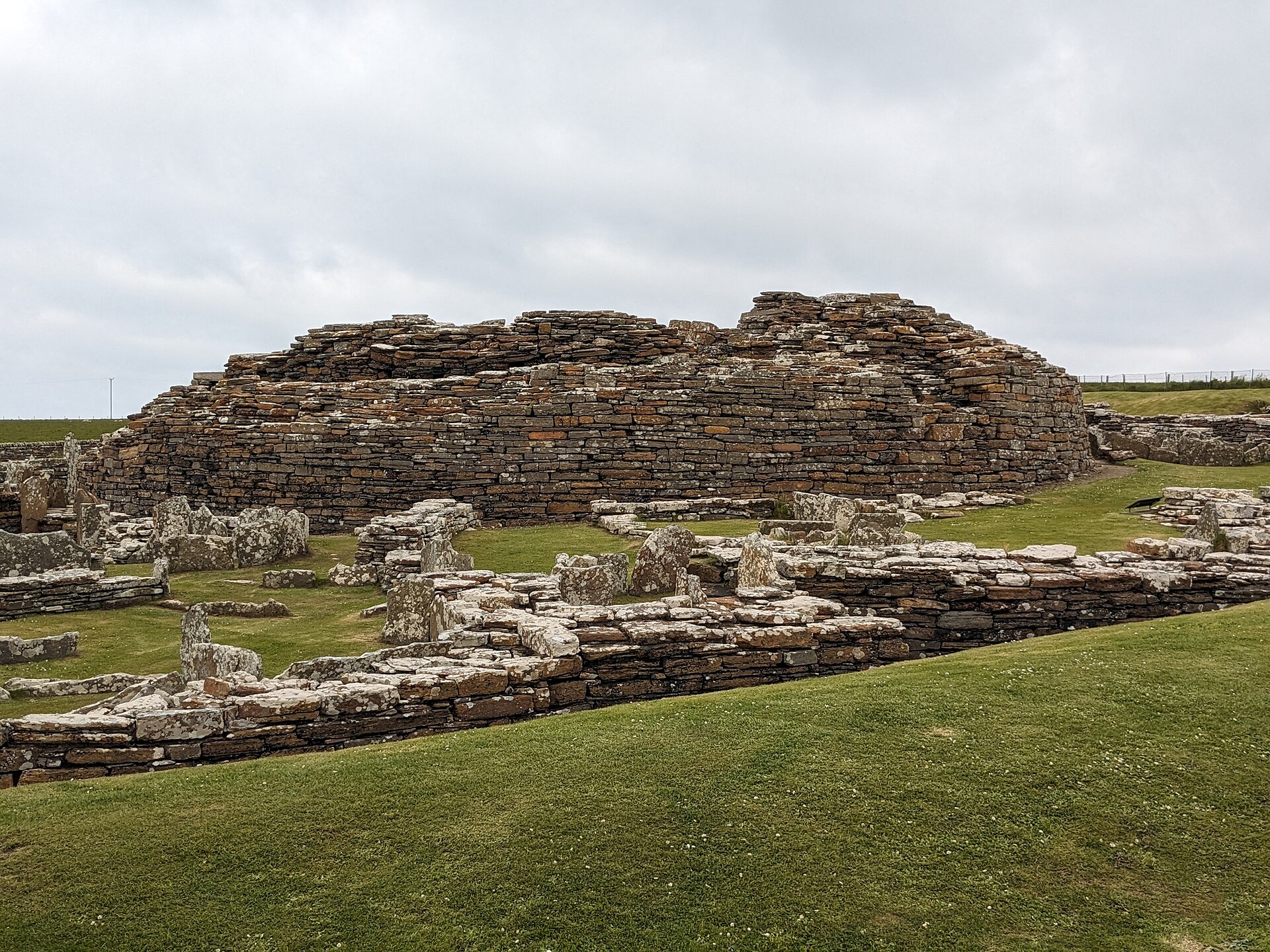
Settlement here began at some point between 500 and 200 BC, on the north-east coast of Mainland Orkney overlooking Eynhallow Sound, about fifteen miles north-west of Kirkwall. The site was not identified until 1929, when the Orkney poet and naturalist Robert Rendall discovered it. At the centre stands a stone tower that probably once reached about ten metres. Its walls are built as two drystone skins with stone-floored galleries running between them, reached by steps. The remains stand up to 3.6 metres high and the walls are up to 4.1 metres thick.
The interior was divided by upright slabs, and stone ledges indicate an upper storey carried on a timber floor. The roof, probably conical or slightly hyperbolic, would have been thatched, with a wall walk around it linked by stairs to the ground floor. There were two hearths. Beneath the tower is a subterranean stone cistern with steps leading down into it, closely resembling the arrangement at Mine Howe. It is thought to carry some religious meaning, connected with an Iron Age cult of the underground.
The tower is only the middle of it. Gurness was a broch village, housing a substantial community, and the tower is generally read as the residence of the principal family or clan of the district — and as the last resort for everyone else if the settlement were attacked.
People
-
Robert Rendall
Orkney poet and naturalist who discovered the broch village in 1929, bringing the buried settlement to archaeological attention.
Cultural influences
-
Broch settlement architecture: a central double-walled tower surrounded by an organised village, ditches and ramparts, which preserves the character of a substantial Iron Age community.
Connections
-

Photo: MichaelMaggs / Wikimedia Commons / CC BY-SA 4.0 Both are major Iron Age brochs in Orkney, preserving the islands’ tradition of monumental fortified settlement.
-

Photo: MichaelMaggs / Wikimedia Commons / CC BY-SA 4.0 Knowe of Yarso chambered cairn
The broch and chambered cairn represent different phases of prehistoric occupation and ritual activity in Rousay’s archaeological landscape.
-
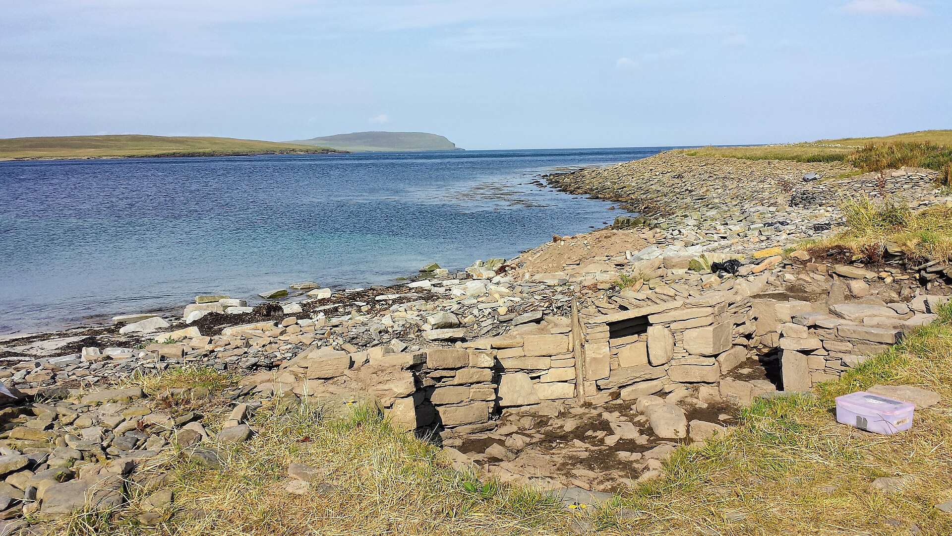
Photo: Bronwyn Chomitz / Wikimedia Commons / CC BY-SA 4.0 Both sites contribute to the long archaeological record of settlement and activity around Rousay’s coast.
Discovery & excavation
The broch village was discovered in 1929 by the Orkney poet and naturalist Robert Rendall.
What to look for
-
The double-walled broch
The central tower retains two drystone wall skins with stone-floored galleries between them, reached by steps.
-
Subterranean cistern
Steps descend to the unusual stone cistern beneath the tower, comparable to Mine Howe.
-
The defended village
Look beyond the tower for the small stone dwellings, yards and sheds arranged inside three rock-cut ditches and stone ramparts.
Plan your visit
- Location
- 59.1240°N · 3.0817°W
- Nearest settlement
- Evie
- Access
- Paid entry — managed visitor site
- Terrain
- Moderate walking
- Start point
- Aikerness · Evie · Orkney · KW17 2NH · National Grid reference: HY 381 268 · Telephone: 01856 751 414 · The roads around the Broch of Gurness are not suitable for coaches. Minibuses up to 22 seats can be accommodated.
- Time needed
- About 90 minutes
- Best time
- 1 April to 30 September: Daily, 10am to last entry at 4pm (closes 4.30pm). Closed for lunch 12.30pm to 1pm. _Opening times and admission prices are subject to change._ Opening times 1 Apr to 30 Sept: Daily, 10am to last entry at 4pm (closes 4.30pm).
- What survives
- The central broch and surrounding settlement survive as exposed stone ruins, including circular walls, passageways, small houses and yards beside Eynhallow Sound.
- Facilities
- Visitor facilities depend on the current heritage-site operation; check the official information before travelling.
- Start point
- Broch of Gurness car park — Historic Environment Scotland car park immediately beside the monument; postcode KW17 2NH and grid HY 381 268 are from the official HES getting-here page.
- Sat-nav
- KW17 2NH
Opening & admission
Free entry
- 1 April to 30 September: Daily, 10am to last entry at 4pm (closes 4.30pm).
- Closed for lunch 12.30pm to 1pm.
- _Opening times and admission prices are subject to change._ Opening times 1 Apr to 30 Sept: Daily, 10am to last entry at 4pm (closes 4.30pm).
Nearby places

Tomb or burial place · Prehistoric
Knowe of Yarso chambered cairn
Orkney Islands
Knowe of Yarso preserves a burial mound built around a stone chamber, bringing together material remains and documented history that illuminate Ork…
- Rough ground
Ancient place · Prehistoric
Knowe of Swandro
Orkney Islands
Knowe of Swandro is a coastal archaeological site on Rousay, where a burial tomb, settlement remains and Viking-age buildings are being eroded by t…
- Rough ground
Tomb or burial place · Prehistoric
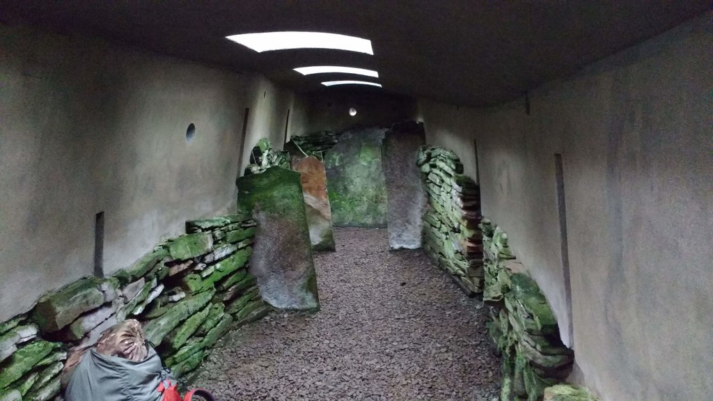
Blackhammer Chambered Cairn
Orkney Islands
Blackhammer Chambered Cairn preserves a Neolithic, the late Stone Age, burial monument dating from roughly 4000–2500 BC, on Rousay in Orkney.
- Some walking
Tomb or burial place · Prehistoric
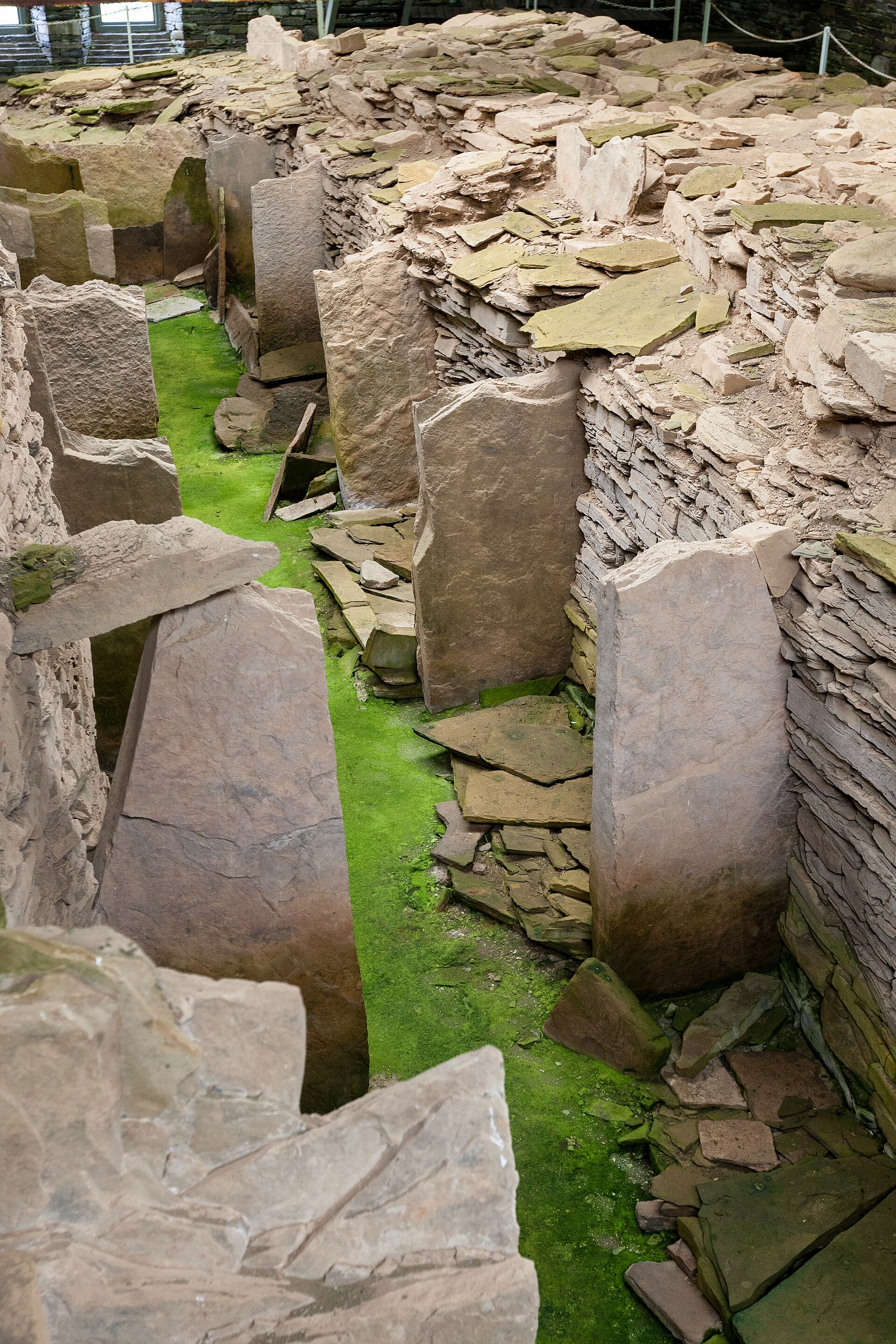
Midhowe Chambered Cairn
Orkney Islands
A large burial mound with an internal stone chamber on the south shore of Rousay, named after the drystone tower beside it.
- Near Rousay
- 10 min walk from car park
- Easy path
Questions people ask
- When was the site found?
- Not until 1929, when the Orkney poet and naturalist Robert Rendall discovered it. Settlement here had begun at some point between 500 and 200 BC, on the north-east coast of Mainland Orkney overlooking Eynhallow Sound, about fifteen miles north-west of Kirkwall.
- How was the tower built?
- Its walls are two drystone skins with stone-floored galleries running between them, reached by steps; the remains stand up to 3.6 metres high with walls up to 4.1 metres thick, and the tower probably once reached about ten. Upright slabs divided the interior, and stone ledges indicate an upper storey on a timber floor.
- What is the cistern beneath it?
- A subterranean stone chamber with steps leading down into it, closely resembling the arrangement at Mine Howe. It is thought to carry some religious meaning, connected with an Iron Age cult of the underground.
Sources
The Ancient Codex, in your pocket
Get the Pocket Codex app
Carry the directory with you — Broch of Gurness and thousands of ancient places across Britain and Ireland, offline, wherever you roam.