
A rare surviving 'semi-broch' — the transitional D-shaped form that shows how the great circular broch towers of the Highlands may have evolved.
Set hard against the lip of a precipice above a small Highland stream, one straight wall of this ancient fort was built to follow the very edge of the drop, leaving no room to be outflanked from the east. The rest of the structure curves around it in a broad D-shape, its dry-stone walls hollow rather than solid — a technique of building two skins of stone with a gap and internal stairs between them, the same trick later perfected in the towering brochs of the region.
Inside, three doorways lead off the inner wall face, one partly roofed with stone lintels at the south-east forming what appears to be the main entrance, and a second opening at the west end. The interior today is choked with fallen rubble, but traces of an upper gallery — a walkway built within the thickness of the wall itself — can still be picked out high on the surviving south side. The fort measures only about 17 by 12 metres, modest beside its two famous neighbours, Dun Telve and Dun Troddan, which stand on easier, flatter ground further down the same glen; this one was built instead on rising, broken terrain, as if defence mattered more here than convenience.
No excavation has ever been carried out at the site, so its builders, its date, and the length of time it was occupied all remain unknown. What survives is the record of others looking at it: an eighteenth-century antiquarian’s brief note, and a Victorian surveyor’s careful drawing a century and a half later, both preserved long after the people who raised the walls had gone.
What follows is drawn from published sources, with each claim labelled by how firmly it is established.
History
In 1720 the antiquarian Alexander Gordon produced the earliest known written reference to the site, recording it under the name 'Castle Chonil' and taking care to describe it as a separate structure from the other two brochs standing further along the same glen. For more than a century afterwards, Gordon's brief note remained the only documentary trace that the fort existed at all.
The first modern survey did not follow until 1871, when the antiquary Henry Dryden examined the ruin in detail and recorded its distinctive D-shaped plan, its hollow double-skinned walls, and the mass of rubble filling its interior. Dryden's work placed the site within the wider study of Highland broch architecture as a possible early or transitional form, though no excavation has followed since, and the questions his survey could not answer — who built it, and when — remain open today.
People
-
Alexander Gordon
Antiquarian who made the earliest known written record of the site in 1720, naming it 'Castle Chonil'.
-
Henry Dryden
Conducted the first modern archaeological survey of the site in 1871.
Cultural influences
-
An early form of broch building
Its D-shaped double-skinned walls and gallery anticipate the construction of later brochs, while the cliff edge supplied one side of its defences.
Connections
-
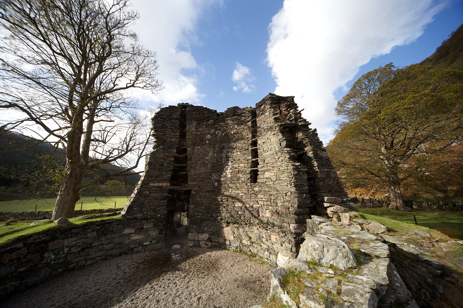
Photo: Tom Parnell from Scottish Borders, Scotland / Wikimedia Commons / CC BY-SA 2.0 One of two well-known brochs standing in the same glen, though sited on flatter, more accessible ground than this fort.
-
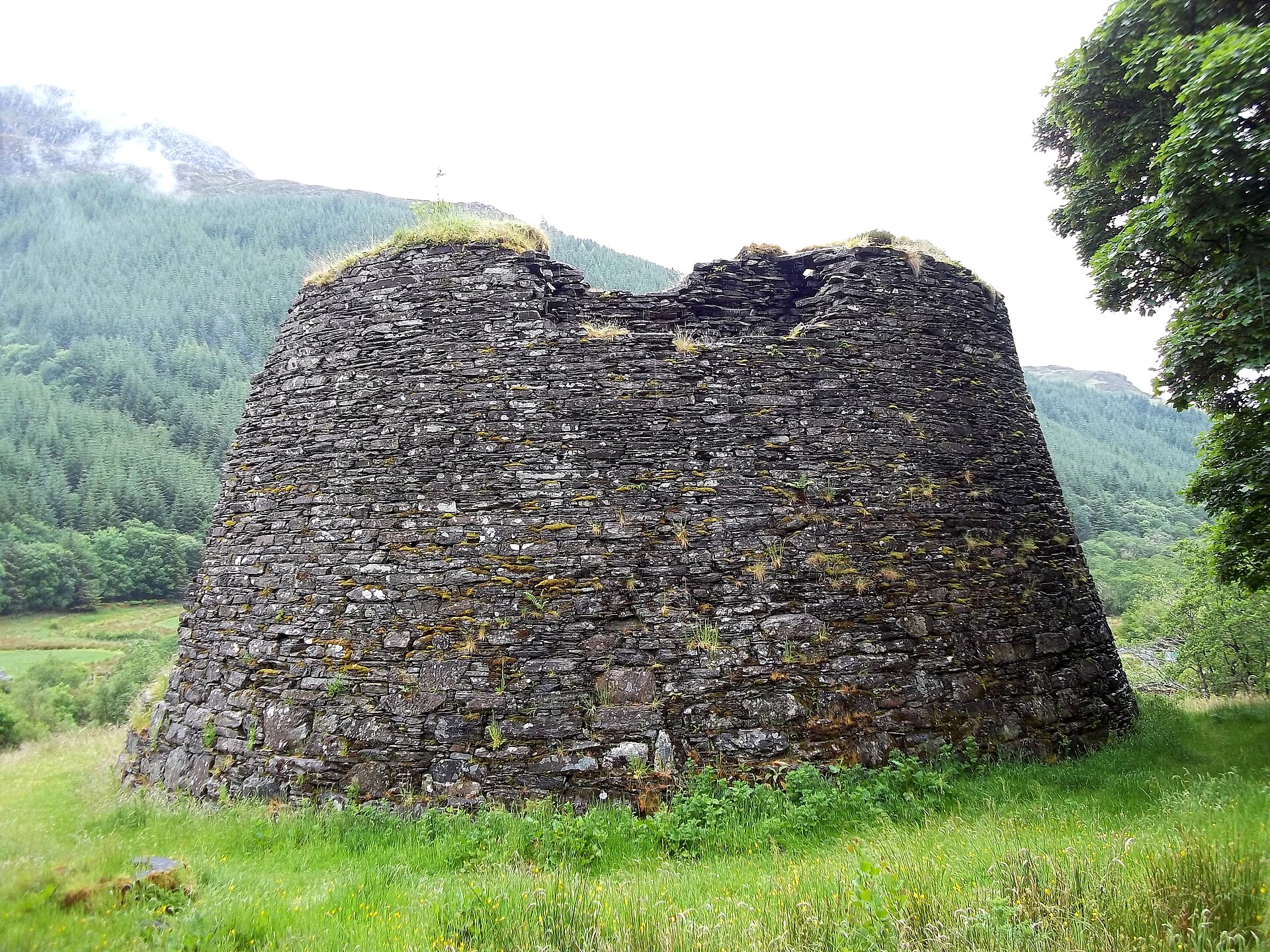
Photo: Pasicles / Wikimedia Commons / CC0 The second of the two nearby Glenelg brochs sharing the same valley, also built on easier ground than this hillside site.
-

Photo: Chris Denny derivative work: Pasicles (talk) / Wikimedia Commons / CC BY-SA 2.0 A separate broch of a very similar name a few miles to the north, distinct from this site and not to be confused with it.
Discovery & excavation
The site has never been excavated. Its existence entered the historical record only through Alexander Gordon's brief description in 1720, and it was not properly surveyed until Henry Dryden's visit in 1871, which produced the first detailed account of its layout and construction.
What to look for
-
The precipice-edge wall
The straight side of the fort runs directly along the edge of a steep drop, using the terrain itself as a defence on that flank.
-
Hollow-wall construction
The walls are built as two stone skins with a gap between them, the same double-wall technique used in later, fully developed broch towers.
-
Two entrances
A partly stone-lintelled doorway at the south-east appears to be the main entrance, with a second opening at the west end of the wall.
-
Upper gallery traces
On the high surviving wallhead at the south side, remains of an intramural gallery — a passage built within the wall's thickness — can still be seen.
-
Three inner doorways
Three separate doorways are visible in the inner wall face, though the rubble-filled interior obscures much of the original floor plan.
Plan your visit
- Location
- 57.1836°N · 5.5568°W
- Nearest settlement
- Glenelg
- Access
- Open access
- Terrain
- Rough ground — reasonable boots advised
- Time needed
- About 45 minutes
- Best time
- Daylight, for the lintelled entrance, wall gallery and cliff-edge setting.
- What survives
- The rubble-filled interior obscures much of the plan, but doorways, gallery traces and a high south wallhead remain visible.
Opening & admission
- The broch stands on rugged rising ground in Gleann Beag; expect an uneven rural approach and check lawful access before travelling.
Nearby places
Fortified place · Iron Age
Dun Troddan
Highland
Its stairway still climbs to a first-floor landing inside a wall four and a half metres thick: one of Scotland's most intact broch (a tall circular…
- Near Inverness
- Some walking
Fortified place · Iron Age
Dun Telve
Highland
Its drystone wall still rises over ten metres without a scrap of mortar, making Dun Telve one of the tallest surviving brochs anywhere in Scotland.
- Near Inverness
- Easy path

Fortified place · Iron Age
Caisteal Grugaig
Highland
A drystone tower still rising over its own five-step internal stair and a triangular lintel massive enough to have never needed a keystone.
- Near Shiel Bridge
- Some walking

Building or ruin · Medieval
Eilean Donan Castle
Highland
The castle photographed on countless shortbread tins is barely a century old: a 1930s recreation of a stronghold the Royal Navy blew apart in 1719.
- Near Inverness
The setting
Near Dun Grugaig, about 7 metres away.
Photo: Mick Garratt / Wikimedia Commons / CC BY-SA 2.0
Near Dun Grugaig.
Photo: Trevor Littlewood derivative work: Pasicles (talk) / Wikimedia Commons / CC BY-SA 2.0
Near Dun Grugaig.
Photo: Trevor Littlewood / Wikimedia Commons / CC BY-SA 2.0
Questions people ask
- What kind of structure is Dun Grugaig?
- A D-shaped dry-stone fort known as a 'semi-broch', a form thought to be a prototype for the fully developed circular broch towers of the Highlands.
- Where is Dun Grugaig located?
- On rugged rising ground above a stream in the upper reaches of Gleann Beag, near Glenelg in the Scottish Highlands.
- Has Dun Grugaig been excavated?
- No. The site has never been excavated, so its construction date and building sequence remain unknown.
- How does it relate to Dun Telve and Dun Troddan?
- All three stand in the same glen, but Dun Grugaig sits on broken, rising ground, while the other two occupy flatter, more accessible sites nearby.
- Is Dun Grugaig the same as Caisteal Grugaig?
- No. Caisteal Grugaig is a separate broch a few miles to the north and should not be confused with this site.
Sources
The Ancient Codex, in your pocket
Get the Pocket Codex app
Carry the directory with you — Dun Grugaig and thousands of ancient places across Britain and Ireland, offline, wherever you roam.