
Fortified place · Iron Age · Scottish Borders
White Meldon
Four concentric rampart (the raised bank thrown up around a fortified enclosure) lines and at least 29 round-house platforms make this one of the largest hillforts in the Scottish Borders, its full building sequence still unresolved.
Climb the flank of White Meldon above the Meldon Burn and the hillside resolves into ring after ring of tumbled stone and earth, four separate lines of defence stacked one inside the other around the summit. Within the best-preserved of these walls, a band of stone about three and a half metres thick enclosing nearly three hectares, the ground is pitted with the flattened circles of at least 29 round-houses, some still visible as clear platforms cut into the slope.
The fort was almost certainly not built in a single campaign. Its innermost defences survive only in fragments, while an outer rampart appears never to have been finished at all, suggesting a community that kept enlarging its stronghold in stages rather than laying it out complete from the start. Exactly when each stage was added, and how long the whole sequence took, has never been established with certainty.
Down at the foot of the western slope, on a shelf above the burn, a smaller oval enclosure adds a second chapter to the story: a single rampart up to two metres high, later partly overbuilt by a settlement whose wall reuses the earlier line. A separate cluster of nine house platforms on the north-western slope rounds out a hillside that was clearly occupied, expanded and reused over a long span of time.
What follows is drawn from published sources, with each claim labelled by how firmly it is established.
History
In its earliest recoverable phase, the community on White Meldon enclosed only the innermost part of the hilltop, and even that first circuit now survives as no more than incomplete traces of walling rather than a continuous line. Whatever structures stood inside this earliest enclosure have left little visible trace beyond the fragments of rampart that mark its rough extent.
At a later stage, the builders added a substantial new circuit further down the slope: a stone wall roughly three and a half metres wide, running about 260 metres north to south and 167 metres east to west, enclosing close to three hectares. This wall today survives in a ruined state but as a continuous, traceable line, unlike the incomplete inner defences it was built to supersede or supplement.
Within that enclosed area the community built round-houses in some number, and the remains of at least 29 of them can still be made out on the ground, several surviving as well-defined circular platforms cut into the hillside. Their number and density suggest a settlement of real size rather than a small refuge, occupied long enough for dozens of individual dwellings to leave a lasting mark.
At the latest stage identifiable in the earthworks, an outermost rampart was begun around the hill, but only fragments of it now survive, and it appears from their patchy distribution that this final, most ambitious ring may never have been completed. Why the work stopped is not recorded, only that the fort's defences ended up larger in plan than they ever were in fact.
Separately from the summit defences, a fortified oval enclosure was built at the foot of the western slope, above the eastern bank of the Meldon Burn, with a single rampart up to about two metres high around an area some 68 metres by 52 metres. This enclosure was later reused: a subsequent settlement occupied more than half of its interior, its wall on the western side built directly onto the earlier rampart rather than replacing it.
A further, apparently separate group of nine house platforms was laid out on the north-western slope of the hill, each some 11 to 18 metres across, distinct from both the summit fort and the lower enclosure. Together the three areas of settlement mark White Meldon as a place returned to and built upon repeatedly, rather than a single fort occupied once and abandoned.
Cultural influences
-
Successive communities enlarged the summit defences and built at least 29 round-houses, later adding settlement areas at the foot and north-western slope of the hill.
Connections
-
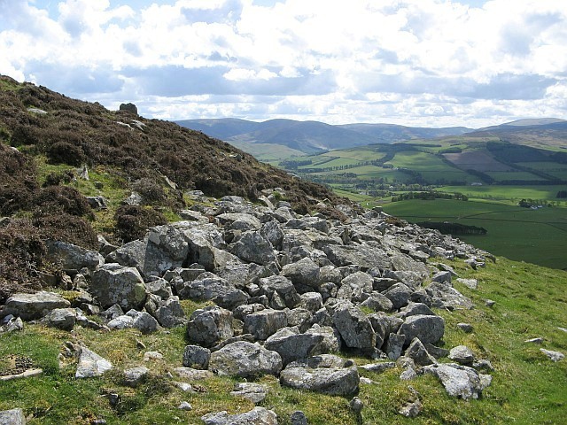
Photo: Eileen Henderson / Wikimedia Commons / CC BY-SA 2.0 A second hillfort stands on the neighbouring hill about a mile to the west, across the Meldon Burn from White Meldon.
-
Fortified enclosure, Scheduled Monument SM3165
A separate oval enclosure at the foot of White Meldon's western slope, above the Meldon Burn, is scheduled in its own right and was later partly reoccupied by a settlement built against its rampart.
-
House platform group, Scheduled Monument SM2712
A group of nine house platforms on the north-western slope of White Meldon is scheduled separately from the summit hillfort itself.
What to look for
-
The four concentric ramparts
Four lines of defence ring the summit, though only the third of these survives as a continuous, ruined wall about 3.5 metres wide; the innermost two are fragmentary and the outermost survives only in patches.
-
Round-house platforms
Inside the main enclosed area, at least 29 round-houses have left their mark on the ground, a number of them visible as clearly defined circular platforms.
-
The lower fortified enclosure
On a shelf above the Meldon Burn at the foot of the western slope sits a separate oval enclosure with a single rampart up to about 2.1 metres high, later partly built over by another settlement.
-
The house platform group
On the north-western slope, nine further house platforms between 11 and 18 metres across form a distinct settlement area from the summit fort.
Plan your visit
- Location
- 55.6728°N · 3.2428°W
- Access
- Open access
- Terrain
- Rough ground — reasonable boots advised
- Time needed
- About 60 minutes
Opening & admission
- Large upland hillfort landscape; use responsible Scottish outdoor access and expect rough ground.
Nearby places

Fortified place · Iron Age
Black Meldon
Scottish Borders
A hillfort whose seven round houses survive as ring-grooves: and five of them stand in a deliberate straight line.
- Rough ground
Fortified place · Medieval
Neidpath Castle
Scottish Borders
A single L-plan tower rebuilt almost nowhere else in its 750-year life, whose carved archway still names both families that shaped it: the Hays' go…

Fortified place · Iron Age
Milkieston Rings
Scottish Borders
A small hillfort of the Iron Age, roughly 800 BC until the Roman conquest: a settlement defended by banks and ditches on high ground: with up to si…
- Rough ground

Fortified place · Medieval
Drochil Castle
Scottish Borders
A palace-like fortress with a corridor running the full length of every floor: its builder's execution left the ambitious design frozen half-finish…
The setting
Moorland on White Meldon summit, the setting of the hillfort.
Photo: Jim Barton / Wikimedia Commons / CC BY-SA 2.0
White Meldon and the Meldon Burn in the hillfort setting.
Photo: Alan O'Dowd / Wikimedia Commons / CC BY-SA 2.0
Heather-covered slope of White Meldon, approached across the moorland.
Photo: M J Richardson / Wikimedia Commons / CC BY-SA 2.0
Rocky summit of White Meldon, with the trig point above the hillfort setting.
Photo: Jim Barton / Wikimedia Commons / CC BY-SA 2.0
Questions people ask
- What kind of site is White Meldon?
- It is a large prehistoric hillfort near Lyne in the Scottish Borders, with four concentric lines of defence and the remains of at least 29 round-houses inside.
- How big is the hillfort at White Meldon?
- Its main surviving wall encloses about 260 by 167 metres, roughly 2.9 hectares, though an unfinished outer rampart suggests the fort was planned even larger.
- How many round-houses are there at White Meldon?
- At least 29 round-houses have been identified within the fort, some surviving as well-defined platforms cut into the hillside.
- Is White Meldon connected to Black Meldon?
- Yes, a second hillfort stands on the neighbouring hill of Black Meldon, about a mile to the west, on the other side of the Meldon Burn.
- Are there other ancient remains near White Meldon?
- Yes, a separately scheduled fortified enclosure lies at the foot of the western slope, and a group of nine house platforms sits on the north-western slope.
Sources
The Ancient Codex, in your pocket
Get the Pocket Codex app
Carry the directory with you — White Meldon and thousands of ancient places across Britain and Ireland, offline, wherever you roam.