
Croft Moraig is a complex multi-phase monument. Excavation in 1965 revealed three phases of construction: first a horseshoe of fourteen timber posts (about 8 m by 7 m) with a central boulder and…
Four miles south-west of Aberfeldy, beneath steep mountainsides on low ground near Loch Tay, twelve dark schist uprights ring a horseshoe of eight more — the third and last arrangement to occupy this ground.
The circle stands beside the A827 between Aberfeldy and Kenmore, north-east of Loch Tay, on low ground beneath steep mountainsides.
It is a complex multi-phase site and shows many features typical of the area: a recumbent stone, graded circle-stones, a south-south-west orientation, quartz pebbles and an outer stony bank. The stones are of dark grey schist.
Excavation in 1965 established three phases of construction. In the first, fourteen timber posts were arranged in a horseshoe measuring eight metres by seven, with a post set just inside the mouth of the horseshoe and, at its centre, a boulder with burnt bone near it. In the second, the timber posts were replaced by a horseshoe setting of eight standing stones, about eight metres by six, surrounded by a stone bank some seventeen metres across; on top of that bank, to the south-west, stood a two-metre stone bearing twenty-three cup marks. In the third phase a circle of twelve standing stones about twelve metres in diameter was raised around the horseshoe, with an entrance in the south-east marked by two external stones and two adjacent graves.
What follows is drawn from published sources, with each claim labelled by how firmly it is established.
History
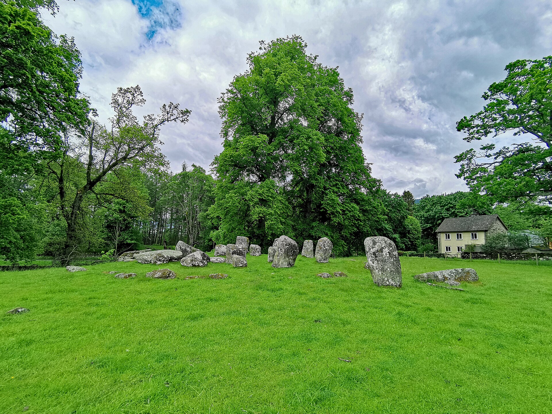
Croft Moraig is a complex multi-phase monument. Excavation in 1965 revealed three phases of construction: first a horseshoe of fourteen timber posts (about 8 m by 7 m) with a central boulder and burnt bone nearby; then the posts were replaced by a horseshoe of 8 standing stones (about 8 m by 6 m) ringed by a stone bank around 17 m across; and finally a circle of 12 standing stones about 12 m in diameter was raised around the horseshoe. Pottery sherds recovered from phase 2 of the site provided dating evidence pointing to around 2000 BC.
People
-
Stuart Piggott
Archaeologist who excavated Croft Moraig in 1965 and, with D. D. A. Simpson, published the sequence of timber and stone monuments.
-
D. D. A. Simpson
Archaeologist and co-author of the 1971 publication on the 1965 excavation at Croft Moraig.
Cultural influences
-
The circle shows several features typical of stone circles in its area: a recumbent stone, graded circle-stones, a south-southwest orientation, quartz pebbles and an outer stony bank.
Connections
-

Photo: Anne Burgess / Wikimedia Commons / CC BY-SA 2.0 The stone circle and castle represent different periods of monument building and power in the Highland landscape around the Tay valley.
-

Photo: Paul Hermans / Wikimedia Commons / CC BY-SA 3.0 Both are landmarks in the long-occupied Highland landscape, linking prehistoric ritual monumentality with a tree embedded in later tradition.
-

Photo: Eusebius / Wikimedia Commons / CC BY 3.0 Croft Moraig and Blair Castle belong to the same Perthshire Highland landscape, contrasting prehistoric ceremonial use with later aristocratic estate power.
Discovery & excavation
The monument was excavated in 1965, which established its three structural phases and recovered phase-2 pottery sherds dated to around 2000 BC.
What to look for
-
The outer circle
An outer circle of 12 standing stones, roughly 12 m in diameter, of dark grey schist.
-
The inner horseshoe
An inner horseshoe setting of standing stones enclosed by a stone bank about 17 m across — the earlier phase the outer circle was built around.
-
The cup-marked stone
To the southwest, on top of the bank, a roughly two-metre stone bearing 23 cup marks.
-
The entrance stones
On the southeast side, an entrance marked by two external (outlying) stones, with two adjacent graves.
-
The ground above Loch Tay
Its setting: low ground northeast of Loch Tay, beneath steep mountainsides, beside the A827 between Aberfeldy and Kenmore.
Plan your visit
- Location
- 56.6018°N · 3.9602°W
- Nearest settlement
- Kenmore
- Access
- Visible from a public way
- Terrain
- Easy going
- What survives
- The stones and low bank survive in an open roadside setting. One of the south-east outlying slabs is fallen, while cup marks are visible on the prominently sited south-south-west stone.
- Start point
- Kenmore village (nearest settlement) (parking unconfirmed) — Stone circle stands immediately beside the A827 between Kenmore and Aberfeldy; no dedicated visitor car park is confirmed. Kenmore is the nearest settlement.
Nearby places

Fortified place · Medieval
Castle Menzies
Perth and Kinross
A sixteenth-century Z-plan seat of the Menzies chiefs, sold off in pieces after 1910 and bought back by the clan society half a century later.
- Near Weem

Ancient tree · Medieval
Fortingall Yew
Perth and Kinross
Fortingall Yew is a named yew tree beside the church at Fortingall in Perth and Kinross. Its precise age is not independently confirmed here.
- Near Fortingall

Fortified place · Medieval
Blair Castle
Perth and Kinross
The ancestral home of Clan Murray and historic seat of the Dukes of Atholl.
- Near Blair Atholl
.jpg?width=800)
Ancient tree · Medieval
Neil Gow's Oak
Perth and Kinross
A bench beneath this oak was engraved with a line from a Michael Marra song about sitting under it with Niel Gow's ghost. A falling branch destroye…
- Near Dunkeld
Questions people ask
- How old is Croft Moraig Stone Circle?
- The pottery from its second construction phase points to about 2000 BC, at the transition between the third and second millennia BC.
- What makes the circle unusual?
- It was built in three phases: timber posts, then an inner stone horseshoe and bank, followed by the outer circle. It is one of Scotland’s most complete examples of this type.
- Who excavated Croft Moraig?
- Stuart Piggott and D. D. A. Simpson excavated the site in 1965 on behalf of the Department of Education; their work established the multi-phase sequence.
- What should visitors look for?
- Look for the inner horseshoe, the outer circle, the cup-marked stone on the south-south-west bank and the outlying entrance slabs to the south-east.
Sources
- Canmore site record 24891 (accessed 2026-06-13)
- Trove (HES) record (accessed 2026-06-13)
- HES designation SM5024 (accessed 2026-06-13)
- Wikipedia: Croft Moraig Stone Circle (accessed 2026-06-13)
- Wikidata Q1140765 (accessed 2026-06-13)
Explore more: Sacred places · Prehistoric · Perth and Kinross
The Ancient Codex, in your pocket
Get the Pocket Codex app
Carry the directory with you — Croft Moraig Stone Circle and thousands of ancient places across Britain and Ireland, offline, wherever you roam.