
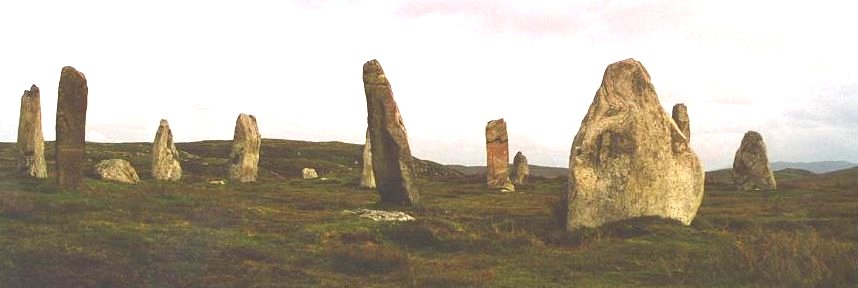
Five stones stand today at Callanish IV, arranged in a pronounced oval measuring 13.3 by 9.5 metres on open moorland southeast of the main Callanish circle. There may once have been as many as thirteen, ranging from 2 to 2.7 metres in height, enclosing a dilapidated cairn (a mound of piled stones, often covering a burial) at the centre in which a small slab, 60 centimetres high, is set on edge. Built during the late Neolithic, around 2750 BCE, the monument is one of several stone settings scattered across western Lewis around Loch Roag, together known as the Callanish complex.
Five stones stand today at Callanish IV, arranged in a pronounced oval measuring 13.3 by 9.5 metres on open moorland southeast of the main Callanish circle. There may once have been as many as thirteen, ranging from 2 to 2.7 metres in height, enclosing a dilapidated cairn at the centre in which a small slab, 60 centimetres high, is set on edge. Built during the late Neolithic, around 2750 BCE, the monument is one of several stone settings scattered across western Lewis around Loch Roag, together known as the Callanish complex.
The circle sits on slightly raised ground within a landscape of peat-covered moorland, broken by low rocky ridges and outcrops of Lewisian gneiss, the ancient bedrock underlying much of the island. A prehistoric quartz quarry lies to the southeast of the monument and the remains of a shieling to the southwest. Archaeologists have suggested that the Callanish monuments were sited to connect different parts of this landscape and to remain visible from a distance, a pattern Callanish IV shares with several of its neighbours, which include Callanish I roughly 3.2 kilometres to the northwest, and Callanish II, III and VIII within a few kilometres.
The site is a scheduled monument, protected since 1992, and is recognised alongside the wider Callanish group as one of the most significant assemblages of Neolithic and Bronze Age monuments in north-western Europe. No excavation has ever taken place at Callanish IV; what is known of it comes from successive archaeological surveys rather than the ground itself, leaving the undisturbed peat around the stones as a reserve of evidence still to be studied.
What follows is drawn from published sources, with each claim labelled by how firmly it is established.
The name
The monument carries several names reflecting different traditions. Callanish IV is the modern archaeological designation, assigned under the numbering system archaeologists use to distinguish the many prehistoric sites of the wider Callanish complex, in which the main circle is Callanish I and nearby sites are numbered as they were identified during survey work. Locally it is also known as Ceann Hulavig, a Scottish Gaelic name in which ceann commonly means "head", "end", or "hilltop", and typically describes the end of a ridge or a prominent point in the landscape. In the official designation entry for the scheduled monument, the site appears under a third name, Sron a'Chail: sron usually means "nose" in Gaelic place names but in geographical use refers to a projecting ridge or promontory, while the second element, a' Chail, denotes a narrow place. Read together, the name can be understood as "the ridge or promontory at the narrow place", a description of the ground on which the stones stand rather than of the monument itself.
History
Callanish IV was raised during the late Neolithic, around 2750 BCE, as an oval ring of standing stones enclosing a small central cairn. It was built as one part of a wider ceremonial landscape taking shape around Loch Roag on western Lewis, alongside the main Callanish circle and the smaller settings later numbered Callanish II, III and VIII. Of the stones originally erected, which may have numbered as many as thirteen, only five remain standing today, ranging from 2 to 2.7 metres in height within an oval measuring 13.3 by 9.5 metres.
The monument's siting appears to have been deliberate rather than incidental. It stands on slightly raised ground amid peat-covered moorland studded with outcrops of Lewisian gneiss, giving it wide views across the surrounding moor, a positioning pattern repeated at several other Callanish sites. A prehistoric quartz quarry was worked to the southeast of the circle, and in a later period a shieling, a seasonal shelter used in transhumance herding, was built to the southwest.
The first formal record of the monument was made in 1914, when the Royal Commission on the Ancient and Historical Monuments of Scotland (RCAHMS) surveyed the site. A further survey followed in the 1970s, carried out by other archaeologists, before RCAHMS returned to record the monument again in 2009. Despite this run of surveys spanning nearly a century, no archaeological excavation has ever been undertaken at Callanish IV, so the deep, undisturbed peat around the stones is thought still to hold buried evidence of the site's original form and of the land use and economy of the surrounding area.
In 1992 the circle and its cairn were designated a scheduled monument, giving them legal protection. The scheduled area is irregular in shape, with its longest extent running 410 metres north to south, and covers not only the stones and cairn but the surrounding ground in which further evidence may survive below the peat, and possibly the sightlines running out from the circle across the landscape. The designation records the site as being of national importance both as a well-preserved field monument in its own right and as a member of the wider Callanish group, describing the complex as one of the most remarkable Neolithic and Bronze Age site assemblages in north-western Europe.
Cultural influences
-
The circle’s raised setting and long-distance visibility link it to the wider Callanish monument complex.
Connections
-
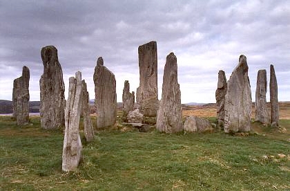
Callanish I (the Callanish Stones)
The main stone circle of the Callanish complex, standing about 3.2 km northwest of Callanish IV; regarded as the best known and largest of the group.
-

Photo: Original uploader was Tumulus at en.wikipedia / Wikimedia Commons / CC BY-SA 3.0 One of the nearby stone settings forming part of the same wider Callanish landscape around Loch Roag.
Discovery & excavation
Callanish IV has never been excavated. What is recorded of it comes from three episodes of survey rather than any dig: RCAHMS first documented the monument in 1914, a further survey was carried out by other archaeologists in the 1970s, and RCAHMS recorded the site again in 2009. The absence of excavation means the deep peat surrounding the cairn remains undisturbed, and the scheduling record notes its potential to yield information about contemporary land use, economy, and possible further structural evidence.
What to look for
-
The five standing stones
An oval ring measuring 13.3 by 9.5 metres, of which five stones remain upright today, standing between 2 and 2.7 metres tall. As many as thirteen may originally have stood.
-
The central cairn and slab
A dilapidated cairn occupies the centre of the ring, within which a small slab, 60 centimetres high, is set on edge.
-
The prehistoric quartz quarry
Located southeast of the circle, this quarry was worked in prehistory and lies within the same immediate landscape as the stones.
-
The shieling remains
The remains of a shieling, a seasonal herding shelter, lie to the southwest of the circle, evidence of the site's much later use in the landscape's farming history.
-
Views across the moor
The circle stands on slightly raised ground within open, peat-covered moorland studded with outcrops of Lewisian gneiss, giving wide views across the surrounding terrain and, from some points, towards other Callanish monuments.
Plan your visit
- Location
- 58.1753°N · 6.7131°W
- Access
- Open access
- Terrain
- Easy going
- Time needed
- About 90 minutes
Nearby places

Sacred place · Prehistoric
Callanish II
Outer Hebrides
Seven thin standing stones rise from a ridge overlooking Loch Roag, on the western side of Lewis, set out in an ellipse measuring 21.6 by 18.9 metr…
- Easy path
Sacred place · Prehistoric
Callanish III
Outer Hebrides
Two concentric ellipses of stone stand on the moor above Loch Roag on the Isle of Lewis, forming Callanish III: Gaelic name Cnoc Fillibhir Bheag. T…
- Easy path
Sacred place · Prehistoric
Calanais Standing Stones
Outer Hebrides
Erected around 2750 BC, before Stonehenge, and laid out so that none of its three stone rows actually points at the centre of its own circle.
- Near Calanais
- 107 metres from car park
- Easy path

Sacred place · Prehistoric
Callanish VIII
Outer Hebrides
Four standing stones rise in a semicircle along a cliff edge on the southern side of Great Bernera, looking out over the narrow strait that separat…
- Easy path
The setting
Track, peat cuttings and a small quarry at Cnoc Dubh near Callanish IV.
Photo: Sandy Gerrard / Wikimedia Commons / CC BY-SA 2.0
Questions people ask
- How old is Callanish IV?
- It was built during the late Neolithic, around 2750 BCE, making it broadly contemporary with the other stone settings in the wider Callanish complex.
- How many stones remain standing at Callanish IV?
- Five stones currently stand, ranging from 2 to 2.7 metres in height, within an oval ring measuring 13.3 by 9.5 metres. There may originally have been as many as thirteen.
- What do the different names for the site mean?
- Callanish IV is the modern archaeological numbering used to distinguish it from the main Callanish circle and other nearby sites. It is also known locally as Ceann Hulavig, and appears in the official scheduled monument record as Sron a'Chail, a Gaelic name understood to mean "the ridge or promontory at the narrow place".
- Has Callanish IV been excavated?
- No. The site has been surveyed three times, by RCAHMS in 1914 and again in 2009, and by other archaeologists in the 1970s, but no archaeological excavation has taken place.
- What other prehistoric features lie near the circle?
- A prehistoric quartz quarry lies to the southeast of the monument and the remains of a shieling to the southwest, while the wider landscape includes the related stone settings of Callanish I, II, III and VIII.
Sources
- Callanish IV — Wikipedia
- Callanish IV — Wikidata (Q2933566)
- Sron a'Chail (Callanish IV) — Scheduled Monument designation record
Explore more: Sacred places · Prehistoric · Outer Hebrides
The Ancient Codex, in your pocket
Get the Pocket Codex app
Carry the directory with you — Callanish IV and thousands of ancient places across Britain and Ireland, offline, wherever you roam.