
Bothwellhaugh Roman Fort reveals how a crossing of the South Calder linked soldiers, cavalry, bathing and the wider Antonine frontier landscape.
At the edge of Strathclyde Loch, Bothwellhaugh Roman Fort occupies ground once overlooking the crossing of the South Calder Water near its meeting with the Clyde. The landscape around it has changed radically: Bothwellhaugh village was flooded to create the loch, but the fort’s position still explains its importance beside a Roman road known as Watling Street. Its scheduled status recognizes a strategic site now framed by country park.
Excavation has made the fort more than an outline on a map. Rediscovered in 1925, it had a scalene right-quadrilateral plan large enough for troops and cavalry. A bathhouse found beneath a pond in 1973 was excavated, moved to higher ground and opened to the public; its rooms, furnace and plunge bath add unusually vivid evidence for military routines. Finds now at the Hunterian Museum connect the site to Antonine-period occupation while leaving its precise relationship to the Antonine Wall open to study.
What follows is drawn from published sources, with each claim labelled by how firmly it is established.
History
Before Strathclyde Loch was created, the fort overlooked the place where the Roman road crossed the South Calder Water close to its confluence with the River Clyde. The road was known as Watling Street and appears on older maps made before the Clyde was diverted and before the fort was rediscovered. This setting gives the fort strategic meaning: it was positioned to observe and use a key river crossing rather than simply occupying an arbitrary point in the landscape.
A Roman structure had been mentioned in the Dalziel section of the Old Statistical Account, but J. M. Davidson rediscovered the fort in 1925. The fort’s scalene right-quadrilateral plan was large enough to house troops and cavalry. Its probable road links north toward Antonine Wall sites and south to Castledykes suggest it belonged within a wider military network, though the source stresses that precisely how these sites were connected remains a subject of ongoing research.
In November 1973 a Roman bathhouse was found beneath a pond between the fort and the medieval structure called Roman Bridge. Full excavation followed in 1975–76 under Lawrence Keppie. The bathhouse was moved to higher ground in 1980 and is open to the public. Its vestibule, cold room, two warm rooms, hot room, hot bath and furnace could perhaps serve about twenty soldiers at a time, preserving an intimate dimension of Roman military life.
People
-
J. M. Davidson
Rediscovered the fort in 1925 after an earlier Roman structure had been noted in the Old Statistical Account.
-
Lawrence Keppie
Directed the 1975–76 excavation of the Roman bathhouse discovered beneath a pond between fort and Roman Bridge.
Cultural influences
-
The fort and its bathhouse express the needs of a Roman garrison controlling a river crossing: accommodation for troops and cavalry, a road connection, and provision for washing and heating.
Connections
-
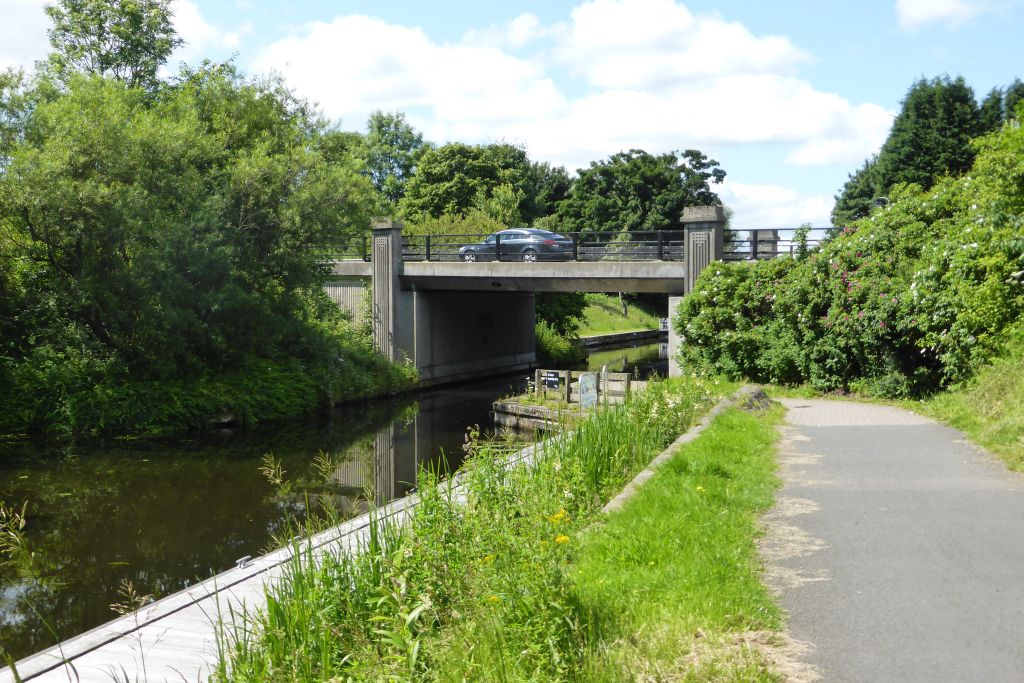
Photo: Robert Murray / Wikimedia Commons / CC BY-SA 2.0 Glasgow Bridge fort guarded a crossing on the Antonine Wall, while Bothwellhaugh overlooked the Roman-road crossing of the South Calder Water; both show Roman military control of route crossings in central Scotland.
-

Photo: Otter / Wikimedia Commons / CC BY-SA 3.0 Bothwell Castle stands on a high bank above the River Clyde, while Bothwellhaugh commanded the South Calder’s confluence with the Clyde; they represent Roman and medieval fortification of the same river corridor.
-
.jpg?width=320)
Photo: Bewahrerderwerte / Wikimedia Commons / CC BY-SA 4.0 Glasgow Cathedral is the medieval religious focus of the Clyde valley, whereas Bothwellhaugh preserves its earlier Roman military landscape; the connection is chronological and regional rather than institutional.
Discovery & excavation
J. M. Davidson rediscovered the fort in 1925; the separate bathhouse was found beneath a pond in 1973 and excavated in 1975–76.
What to look for
-
The South Calder crossing
Orient yourself to the South Calder Water and the nearby Strathclyde Loch landscape. The fort once overlooked a crossing close to the Clyde confluence, so the changed waterscape is key to understanding why this location was chosen.
-
The fort’s odd plan
Look for the fort’s broader footprint rather than expecting a standing Roman enclosure. Its scalene right-quadrilateral plan was designed to accommodate both troops and cavalry, but much of its significance comes from archaeological evidence below and around the present ground surface.
-
The moved bathhouse
Visit or observe the relocated Roman bathhouse, which was excavated after discovery beneath a pond. Its sequence of vestibule, frigidarium, two tepidaria, caldarium and praefurnium makes the movement from changing room to heated spaces legible.
-
The plunge bath and furnace
Notice the cold plunge bath, warm rooms, hot room and furnace arrangement in the bathhouse. The possibility that about twenty soldiers used it at a time gives these technical features a human scale and links architecture to regular military care and sociability.
-
What remains unfound
Use the site to consider what remains undiscovered. The distance between the bathhouse and fort suggests other structures may still lie unlocated, while the road relationships to the Antonine Wall and Castledykes remain unresolved.
Plan your visit
- Location
- 55.7940°N · 4.0270°W
- Access
- Open access
- Terrain
- Moderate walking
- Parking
- Use Strathclyde Country Park parking and continue on foot to the bathhouse area.
- Time needed
- About 45 minutes
- Best time
- Daylight, when the relocated bathhouse can be read clearly.
- What survives
- The fort is largely below ground; the relocated bathhouse preserves the visible sequence of Roman changing, cold, warm and hot rooms.
Opening & admission
The fort does not survive as a visitable standing monument; its relocated Roman bathhouse can be seen in Strathclyde Country Park.
- The site is now within Strathclyde Country Park.
- The Roman bath house was moved to higher ground in 1980 and is now open to the public.
- The fort's wider relationship to the Antonine Wall remains under study.
Nearby places

Fortified place · Medieval
Bothwell Castle
South Lanarkshire
A large medieval castle on a high, steep bank above a bend in the Clyde, between Bothwell and Uddingston.
.jpg?width=800)
Building or ruin · Medieval
Glasgow Cathedral
Glasgow City
One of only two medieval Scottish cathedrals: alongside St Magnus in Orkney: to survive the Reformation (the sixteenth-century suppression of monas…
- Near Gloucester
Fortified place · Iron Age
Black Hill (South Lanarkshire)
South Lanarkshire
A hill valued as a viewpoint for four thousand years: with a cairn, a mound of piled stones often covering a burial, that may line up on Tinto to f…
- Some walking
Crossing or structure · Roman
Glasgow Bridge, Kirkintilloch
East Dunbartonshire
Glasgow Bridge marks a largely invisible Antonine Wall fortlet known through aerial evidence, beside a canal crossing that now connects Kirkintillo…
- Near Kirkintilloch
- Easy path
The setting
Near Bothwellhaugh Roman Fort, about 383 metres away.
Photo: Jim Smillie / Wikimedia Commons / CC BY-SA 2.0
Near Bothwellhaugh Roman Fort, about 385 metres away.
Photo: Alan O'Dowd / Wikimedia Commons / CC BY-SA 2.0
Near Bothwellhaugh Roman Fort, about 389 metres away.
Photo: Ralph Greig / Wikimedia Commons / CC BY-SA 2.0
The setting near Bothwellhaugh Roman Fort.
Photo: No machine-readable author provided. Supergolden assumed (based on cop / Wikimedia Commons / CC BY-SA 3.0
The setting near Bothwellhaugh Roman Fort.
Photo: Rosser1954 / Wikimedia Commons / CC BY-SA 4.0
Questions people ask
- Where is Bothwellhaugh Roman Fort?
- It lies in Strathclyde Country Park in North Lanarkshire, east of where the South Calder Water enters Strathclyde Loch, close to Motherwell.
- When was the fort rediscovered?
- J. M. Davidson rediscovered the fort in 1925, following an earlier reference to a Roman structure in the Old Statistical Account.
- What can be seen at the bathhouse?
- The relocated bathhouse includes a vestibule, cold room and plunge bath, two warm rooms, a hot room with hot bath, and a furnace room. It was excavated in 1975–76 and moved in 1980.
Sources
The Ancient Codex, in your pocket
Get the Pocket Codex app
Carry the directory with you — Bothwellhaugh Roman Fort and thousands of ancient places across Britain and Ireland, offline, wherever you roam.