
Camps A and B here are among the best-preserved Roman marching camps in Scotland, and Camp B was deliberately rebuilt inside Camp A rather than laid out fresh.
On a stretch of rough moorland in the Cheviot Hills, rectangular banks and ditches lie one inside another, their corners rounded and their old gateways still visible as gaps cut through the turf. Sheep graze ground that Roman soldiers once flattened for a night or a season’s stay, digging ramparts and ditches before moving on along the road they called Dere Street.
Camp A, the largest of the group, encloses close to eighteen hectares within ramparts up to 4.6 metres wide, its outline still traceable across the moor despite two thousand years of drainage and cultivation nearby. Camp B was built later, tucked into the southeast corner of Camp A and reusing part of its eastern and southern defences — evidence that Roman forces came back to the same patch of ground more than once, adapting an existing camp rather than starting again from bare turf.
Two further camps, C and D, are far less complete: C has been cut into by a forestry plantation and drainage work, while D survives only as a faint turf bank picked out on aerial photographs. Alongside a later farmstead and its rig-and-furrow fields, the site layers Roman campaigning onto centuries of ordinary farming, all crowded onto the same stretch of ground beside the road running north from Tow Ford.
What follows is drawn from published sources, with each claim labelled by how firmly it is established.
History
During Rome's campaigns into southern Scotland, soldiers marching along the road later known as Dere Street threw up a large rectangular camp on a platform of firm ground beside the Kale Water crossing at Tow Ford. Now called Camp A, it enclosed almost eighteen hectares behind ramparts up to 4.6 metres wide and a ditch of similar width, with gateways left open on all four sides so the army could march in and out overnight.
At some later point troops returned to the same ground and built a second, smaller camp in the southeast corner of Camp A, reusing part of its eastern and southern defences rather than laying out an entirely new perimeter. Camp B enclosed only about four hectares, and one of its western gateways was subsequently narrowed, a modification usually read as evidence that the camp saw a further period of reoccupation after its first use.
Long after the Romans withdrew, a farmstead was raised immediately east of the road running between the camps. It grew to at least two buildings and five enclosed fields, with ridge-and-furrow ploughing traced across the enclosed ground — ordinary agricultural life laid directly on top of abandoned military earthworks, with no boundary left in the landscape between the two periods of use.
A linear earthwork was also cut within Camp A itself, running north from a point close to the camp's southwest corner. Too slight to be a defensive work, it is thought to have served as a later land boundary, one more addition to a site that continued to be reshaped by farming and land division long after its original Roman purpose had ended.
In 1774 the military surveyor William Roy became the first to record Camps A and B in detail, as part of the fieldwork behind his broader survey of Roman remains in Britain. His documentation marked the earliest scholarly recognition of Pennymuir as a Roman site, and Camps A and B remain among the best-preserved examples of their kind anywhere in Scotland.
Aerial photography later revealed traces of a probable fourth camp, Camp D, on the opposite side of Dere Street from Camp A. Only its north and east sides survive as a low, spread turf bank, enough to suggest an enclosure of at least 2.3 hectares, while its south and west sides had already been ploughed out and cut through by modern drainage ditches. Camp C, set to the northeast of Camps A and B and straddling the modern road to Hownam, fared worse still: drainage work and a forestry plantation obliterated most of its circuit, leaving only a fifty-metre stretch of turf bank south of the modern road to mark where its western side once ran.
People
-
William Roy
Military surveyor who first recorded Camps A and B in detail in 1774, as part of his wider survey of Roman military remains in Britain.
Cultural influences
-
Successive Roman forces made temporary camps beside the Kale Water crossing on Dere Street, reusing an earlier camp perimeter and modifying its gateways.
Connections
-
Chew Green Roman camps and fortlets
Lie about 7 kilometres southeast of Pennymuir, across the English border, on the same stretch of the Dere Street road system.
-
Woden Law hillfort
An Iron Age hillfort standing in the immediate vicinity of the Pennymuir camps, showing Roman forces camped within a landscape already marked by earlier native fortification.
-

Photo: Hugh Mortimer / Wikimedia Commons / CC BY-SA 2.0 The Roman road along which the Pennymuir camps were built, running north from the Kale Water crossing at Tow Ford and linking the site to Chew Green further south.
Discovery & excavation
Camps A and B were first identified and recorded in 1774 by William Roy. Camp D was found much later, through aerial photography that picked out its faint, spread turf banks on the ground opposite Camp A — traces too slight to have been noticed at ground level after centuries of ploughing and drainage.
What to look for
-
Entrance gaps in Camp A
Gateway breaks are visible on all four sides of Camp A, with two on the west side, marking where the Roman army's marching column entered and left the camp.
-
Camp B's narrowed gate
One of Camp B's western gateways was narrowed at a later date, a visible modification thought to reflect a further period of reoccupation.
-
The farmstead and its enclosures
East of the road between the camps, the low remains of at least two farmstead buildings and five field enclosures survive, with rig-and-furrow cultivation traceable within them.
-
The linear earthwork inside Camp A
A slight bank runs north from near the southwest corner of Camp A, cutting across the interior of the Roman earthwork as a later boundary feature.
Plan your visit
- Location
- 55.4181°N · 2.3882°W
- Access
- Open access
- Terrain
- Rough ground — reasonable boots advised
- Time needed
- About 45 minutes
Opening & admission
- Remote moorland camps beside Dere Street; use responsible access and carry suitable navigation.
Nearby places

Building or ruin · Roman
Chew Green
Northumberland
Chew Green is a complex Roman military landscape on Dere Street near the Scottish border, preserving camps, fortlets, a fort, and a section of road…
Carved stone · Prehistoric
Hownam Rings
Scottish Borders
C. M. Piggott's 1948 excavation at Hownam Rings became a landmark in the archaeology of northern Britain. It produced the 'Hownam model' (or 'Howna…
- Near Hownam
- 1.2 km from car park
- Some walking

Fortified place · Medieval
Cessford Castle
Scottish Borders
A Border Reiver stronghold whose name outlived it: the ruined tower still lends its title to the Duke of Roxburghe, who is Baron Ker of Cessford to…
Building or ruin · Roman
Featherwood Roman Camps
Northumberland
Featherwood Roman Camps preserve two large first-century marching camps on Dere Street, showing how Roman forces moved and maintained a route into…
The setting
Interpretation panel beside the Pennymuir Roman camps, looking across the moorland setting.
Photo: Andrew Curtis / Wikimedia Commons / CC BY-SA 2.0
Pennymuir Village Hall and the surrounding hills near the Roman camps.
Photo: Andrew Curtis / Wikimedia Commons / CC BY-SA 2.0
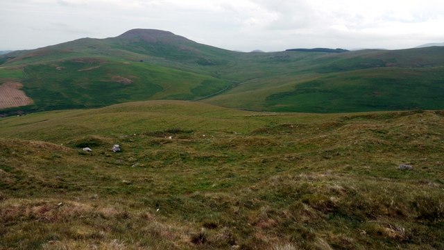
Rough grassland on Pennymuir Rig near the Roman camps.
Photo: Richard Webb / Wikimedia Commons / CC BY-SA 2.0
Questions people ask
- How many Roman camps are at Pennymuir?
- Four temporary camps have been identified, labelled A to D, along with a linear earthwork and traces of rig cultivation, all set beside the Roman road Dere Street.
- Why are there two overlapping camps, A and B?
- Camp B was built later within the southeast corner of Camp A, reusing part of its defences — evidence that Roman forces returned to the site more than once.
- Who first recorded the camps?
- The military surveyor William Roy recorded Camps A and B in 1774, the earliest documented account of the site, as part of his survey of Roman remains in Britain.
- Is Camp D confirmed to be Roman?
- Camp D is described as probable rather than certain: it was identified from aerial photographs, and only part of its bank survives after ploughing and modern drainage removed the rest.
- What lies near the Pennymuir camps?
- The site sits near Woden Law hillfort and roughly seven kilometres from the Roman camps and fortlets at Chew Green across the English border, all linked by Dere Street.
Sources
- Wikipedia: Pennymuir Roman camps
- Historic Environment Scotland — Canmore
Explore more: Fortified places · Roman · Scottish Borders
The Ancient Codex, in your pocket
Get the Pocket Codex app
Carry the directory with you — Pennymuir Roman camps and thousands of ancient places across Britain and Ireland, offline, wherever you roam.