
Torr a’Chaisteal preserves the low, turf-covered defences of an Iron Age (from about 800 BC until the Romans came) dun and its link to Arran’s wider western Scottish settlement tradition.
A grassy knoll on Arran’s west coast holds the low, turf-covered stone walls of Torr a’Chaisteal, an Iron Age dun about two kilometres northeast of Sliddery. The enclosing wall is now only around half a metre high, but its four-metre average width and large sandstone boulders still define a compact defended space. A substantial earthwork (a bank or ditch dug and heaped from the ground itself, with no masonry) on the landward approach adds another clue to how the site was arranged and protected.
This was a fortified residence of a form common in later Iron Age western Scotland, not merely a single isolated pile of stones. Nineteenth-century excavations found human and animal bones, shells, a quern top stone and pieces of haematite iron. Together with the nearby Kilpatrick Dun, the site helps connect a small visible enclosure with patterns of domestic life, food, tools and defence across Arran.
What follows is drawn from published sources, with each claim labelled by how firmly it is established.
History
Torr a’Chaisteal belongs to the later Iron Age tradition of duns, fortified residences common across western Scotland. Its location on an isolated grassy knoll on Arran’s west coast and its enclosing sandstone wall show a deliberate choice of a defensible place. The surviving enclosure is around seven metres across, offering a compact scale for considering how a small household or group could have organized security and daily life within a strongly bounded space.
The structure preserves evidence of more than one defensive element. The main turf-covered wall is around 0.5 metres high today and averages four metres in width, while a short stretch of wall lies east of the dun. On the landward approach a substantial earthwork may have formed an outer defence. These components indicate that approach and perimeter mattered, even though weathering and time have reduced the fortification to low forms in the grass.
Antiquarian excavation in the nineteenth century produced human and animal bones, shells, the top stone of a quern and pieces of haematite iron. The contexts of the individual objects were not preserved in surviving accounts, but the group points to people, animals, food resources, grain processing and mineral use at or around the defended residence.
Cultural influences
-
The turf-covered stone enclosure and possible outer earthwork show how a small western Scottish dun controlled its landward approach.
Connections
-

Photo: Nigel Homer / Wikimedia Commons / CC BY-SA 2.0 Another defended prehistoric site on Arran, offering a comparison with Torr a’ Chaisteal’s hilltop enclosure.
-

Photo: Photograph by Mike Peel (www.mikepeel.net). / Wikimedia Commons / CC BY-SA 4.0 A prehistoric funerary monument in the wider Arran landscape, contrasting with the dun’s defensive purpose.
-
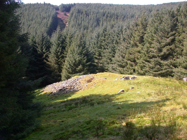
Photo: David G Campbell / Wikimedia Commons / CC BY-SA 2.0 Another prehistoric monument on Arran, helping place Torr a’ Chaisteal within the island’s long archaeological sequence.
Discovery & excavation
Nineteenth-century antiquarian excavation recovered human and animal bones, shells, a quern top-stone and pieces of haematite iron.
What to look for
-
The enclosure on the knoll
Look for the low circular enclosure on the grassy knoll. The walls are turf-covered, so their breadth is as important as their height: they average around four metres wide despite rising only about half a metre above the surrounding ground.
-
The sandstone boulders
Notice the large sandstone boulders that form the wall. Their visible mass helps explain how the dun’s boundary was constructed and why the surviving outline can remain legible even after the upper structure has gone.
-
The small interior
Trace the enclosed interior, which is around seven metres in diameter. This very compact space is a useful counterpoint to the broad outer wall and invites consideration of how little room lay within the fortification.
-
The landward earthwork
Look to the east for the short stretch of wall beside the dun, then toward the landward approach for the substantial earthwork that may have acted as an outer defence. Together they show that the site’s perimeter was not a simple uniform ring.
-
Kilpatrick Dun to the north
Relate the knoll to the west-coast landscape and to Kilpatrick Dun about four kilometres north. The latter is explicitly identified as a similar structure, making the view outward part of understanding the dun’s regional setting.
Plan your visit
- Location
- 55.4590°N · 5.2886°W
- Nearest settlement
- Blackwaterfoot
- Access
- Open access
- Terrain
- Moderate walking
- Time needed
- About 45 minutes
- Best time
- Dry daylight, when the low wall, grassy knoll and landward earthwork are easiest to trace.
- What survives
- A low turf-covered dun retains a roughly seven-metre interior, broad sandstone walling and a possible outer earthwork on the landward side.
Opening & admission
- The dun stands on an isolated grassy knoll on Arran's west coast.
- A landward earthwork may have served as an outer defence.
Nearby places

Fortified place · Iron Age
Kilpatrick Dun
North Ayrshire
Kilpatrick Dun is a substantial later Iron Age (the centuries before Rome arrived, from about 800 BC) fortified residence on Arran, with an eight-m…
- Near Blackwaterfoot
- Some walking

Tomb or burial place · Prehistoric
Torrylin Cairn
North Ayrshire
Torrylin Cairn preserves a Neolithic (the late Stone Age, about 4000–2500 BC in Britain) Clyde cairn whose chamber, burials and later damage reveal…
- Some walking
Tomb or burial place · Prehistoric
Carn Ban, Arran
North Ayrshire
Carn Ban is one of south-west Scotland’s best-known Neolithic (the first farming period in Britain, roughly 4000–2500 BC) Clyde cairns, preserving…
- Near Kilmory
- Easy path

Sacred place · Prehistoric
Machrie Moor Stone Circles
North Ayrshire
Machrie Moor gathers stone circles, burials and earlier timber settings into an exceptional prehistoric (before any written account of Britain exis…
- Near Machrie
- Some walking
The setting
A view from Torr a' Chaisteil across Arran; retained as a contextual landscape view while the direct tor photograph below serves as the lead image.
Photo: habiloid / Wikimedia Commons / CC BY-SA 2.0
Questions people ask
- What is Torr a’Chaisteal?
- It is an Iron Age fort, or dun, on the Isle of Arran. The source describes it as a fortified residence of a type common in later Iron Age western Scotland.
- What survives at the dun?
- Turf-covered sandstone walls around 0.5 metres high and about four metres wide enclose an area roughly seven metres across. A short eastern wall and a substantial landward earthwork also survive.
- What was found in excavations?
- Nineteenth-century antiquarian excavations found human and animal bones, shells, the top stone of a quern, and pieces of haematite iron.
Sources
The Ancient Codex, in your pocket
Get the Pocket Codex app
Carry the directory with you — Torr a'Chaisteal and thousands of ancient places across Britain and Ireland, offline, wherever you roam.